
South Coogee to Kingsford
The South Coogee to Kingsford route provides an east-west connection to the Kingsford light rail terminus travelling along Bundock St, Avoca St and Sturt St.
The 1.9km route is proposed to include a separated cycleway, providing people with a safe, pleasant and healthy alternative to car use for neighbourhood destinations and for longer distance bicycle commuting. The project will also involve streetscape improvements such as new trees, garden beds, footpaths and pedestrian crossings to enhance the amenity of the streets along the route for everyone.
A draft concept was prepared in 2018 and refined in 2019 following community consultation. The revised concept was endorsed by Council in June 2019 and is currently awaiting State Government funding to proceed to construction. There is no set timeframe for this.
Project summary

Download a larger version of the South Coogee to Kingsford cycling improvements map PDF, 319 KB
Project timeline
- Oct 2018 - Draft concept
- Nov 2018 - Community consultation
- Dec 2018 - Tree assessment
- Apr 2019 - Alternate routes considered
- Jun 2019 - Revised concept endorsed by Council
- Current - Detailed Design
Trees
Every one of the up to 37 trees proposed for removal in the initial design concept have been reviewed and assessed by an independent arborist with a view to saving as many possible. Council has listened to the community and modified the design to significantly reduce tree loss. The revised concept plan has resulted in 27 trees saved – most of which are significant trees atmore than five metres in height.
You can view the status of each tree on the interactive Tree Map.
The project is in partnership with Transport for NSW under the Active Transport Program, an initiative to strengthen active transport – that is, walking and cycling – in key areas. In particular, the Transport for NSW program prioritises connections within five kilometres of public transport interchanges such as the Kingsford Light Rail Terminus.
Community consultation
The concept design for the South Coogee to Kingsford cycleway was on public exhibition for community feedback from 30 October to 23 November 2018. Information about the proposal was posted to local residents and ratepayers, advertised in The Southern Courier and every property along the route was door-knocked.
The concept designs were exhibited at Council's Administration Building and Libraries and also online on our consultation website. Your Say - Randwick.
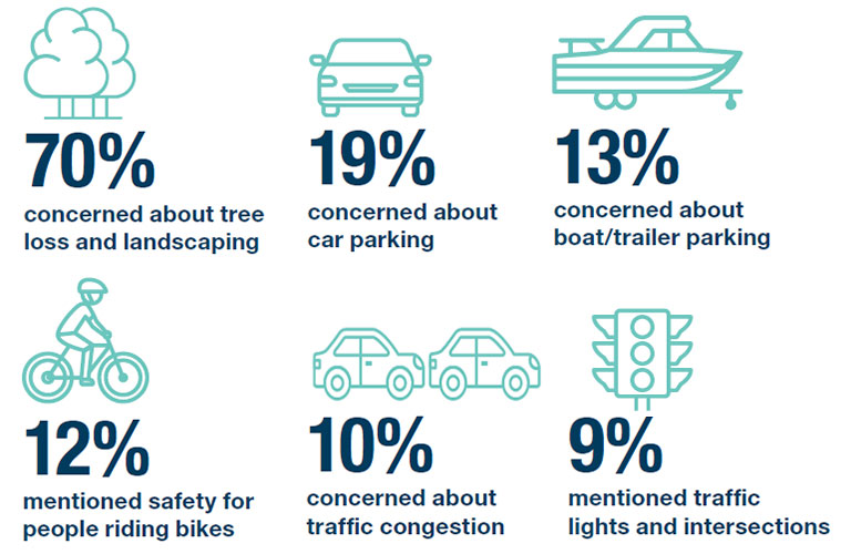
More than 800 submissions were received. The main issues raised were trees, onstreet vehicle parking, safety for bike riders, traffic and congestion, traffic signals and intersections, pedestrian safety and driveway access.
Of the 291 submissions received through Your Say Randwick:
- 43% were supportive
- 20% neutral
- 28% unsupportive
- 9% no view expressed
Of the 473 email submissions received:
- 7% supportive
- 8% neutral
- 85% unsupportive (this includes 348 emails with pre-populated text from a campaign site set by Saving Sydney’s Trees)
You can view all submissions received and Council's response by downloading the following document:
It was clear from the feedback that retaining as many trees as possible is the most important issue for many people. Council staff have considered all the feedback and made amendments to the design concept to improve the design.
Revised Concept Plan (June 2019)
Following community consultation, Council staff have revised the concept plans to respond directly to community concerns.
Key changes include:
- 27 significant trees saved due to redesign
- New areas of shared path on Bundock Street between Avoca and Ellen Streets.
- Pedestrian crossing on Sturt St near Patton moved to save a tree.
Summary of Revised Concept:

Details plans - Revised Concept:

How does a separated cycleway work?
A cycleway that is separated from the footpath and the road significantly reduces the conflict and likelihood of accidents between people who walk, people on bikes and motor vehicles. It is widely acknowledged that providing safe cycling infrastructure is the key to making bike riding a viable transportation option for many in the community.
Riding a bicycle on the road requires a person to mix with traffic, often forcing the bike rider to ride close to parked cars where there is a risk of ‘car dooring’. Separated cycleways have been built throughout Sydney and around the world and can integrate with streets with intersections, driveways and traffic lights.
Feedback from City of Sydney indicates that on many of their separated cycleways the bike trips have increased significantly and crashes have gone down.
Numerous studies have shown that when it comes to riding bicycles in cities people generally fall into one of three groups:
- about 7% are ‘enthused and confident’
- about 33% are characterised as ‘no way, no how’
- and the remaining 60% are characterised as ‘interested, but concerned’.
It’s this majority cohort of people who’d like to ride, but are worried about safety. Separated cycleways make it safer to ride a bicycle as bicycle lanes are separated from moving traffic.
Cities around the world are demonstrating that if you make cycling safer and easier, more people will cycle and this benefits everybody and puts less pressure on our road network.
Project updates and news
- Jun 2019: Revised South Coogee to Kingsford cycleway plan to save 27 mature trees
- May 2019: May Council wrap-up - east west cycleway route chosen
- Apr 2019: Council explores alternative options for east-west cycleway
- Dec 2019: Detailed tree assessment next stage of cycleway project
- Nov 2018: Council seeks feedback on walking and cycling improvements Kingsford to South Coogee
Council reports
- Jun 2019: Revised concept plan and community consultation outcome
- May 2019: Route options analysis
Map of bicycle route construction priority
In 2015, Randwick City Council undertook community consultation to review our bicycle routes, and to establish priorities for constructing bicycle routes within the City. The connection from Centennial Park to Kingsford, and from Kingsford to South Coogee were both identified as high priority routes in the finalised Council network.
Council reports prepared in 2015 provide background information on the priority bicycle routes and are available here:
Works Report No W4/15 to the 10 February 2015 meeting PDF, 669.98 KB
Works Report No W39/15 to the 10 November 2015 meeting PDF, 402.49 KB
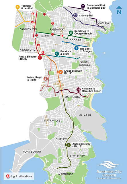
Download a pdf version of the bicycle route construction priority map PDF, 379.34 KB